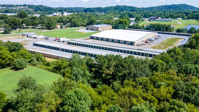
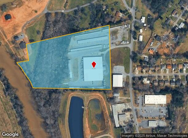
Property Record
676 Mauldin Rd Nw, Calhoun, GA 30701
NEARBY LISTINGS FOR SALE OR LEASE
Property Detail
676 Mauldin Rd Nw
043A-144
LL 155 & 156
Publicstorage
Gordon
AE
Georgia
13213C0275D
12.10 AC
2024
Georgia Northwest
2024
Other Market Areas
970302
Calhoun, GA
30,000 SF
DEMOGRAPHICS near 676 Mauldin Rd Nw
1 mile
3 mile
5 mile
2024 Total Population
4,177
23,278
33,534
2029 Population
4,486
24,946
35,922
Pop Growth 2024-2029
+ 7.40%
+ 7.17%
+ 7.12%
Average Age
37
38
39
2024 Total Households
1,544
8,594
12,412
HH Growth 2024-2029
+ 7.25%
+ 6.96%
+ 6.92%
Median Household Inc
$34,802
$44,422
$48,016
Avg Household Size
2.60
2.60
2.60
2024 Avg HH Vehicles
1.00
2.00
2.00
Median Home Value
$159,032
$178,504
$178,356
Median Year Built
1991
1986
1985
Nearby Places
Map Layers
Map Styles
 Street
 Aerial
Transit
 Traffic
 Biking
Places
Listings with unknown addresses are not visible on the map
- Restaurants
- Banks
- Shops
- Fitness
- Groceries
SALE & LEASE HISTORY
LISTING DATE
SALE/LEASE

Aug 19, 2022
For Sale
Nearby Properties
Address
Land Use
TOTAL SIZE
Lot Size
Zoning
Address
Land Use
TOTAL SIZE
Lot Size
Zoning
5,040 SF
13.39 AC
C-2
Address
Land Use
TOTAL SIZE
Lot Size
Zoning
215,296 SF
19.94 AC
R-2
Address
Land Use
TOTAL SIZE
Lot Size
Zoning
209,387 SF
42.22 AC
R-1
Address
Land Use
TOTAL SIZE
Lot Size
Zoning
18,640 SF
75.10 AC
C-2
Address
Land Use
TOTAL SIZE
Lot Size
Zoning
192,578 SF
25.47 AC
C-N
Address
Land Use
TOTAL SIZE
Lot Size
Zoning
197,500 SF
14.55 AC
IND-G
Address
Land Use
TOTAL SIZE
Lot Size
Zoning
85,560 SF
3 AC
C-2
Address
Land Use
TOTAL SIZE
Lot Size
Zoning
4,318 SF
19.26 AC
IND-G
Address
Land Use
TOTAL SIZE
Lot Size
Zoning
26,922 SF
19.71 AC
C-4
Address
Land Use
TOTAL SIZE
Lot Size
Zoning
554,897 SF
42.41 AC
IND-G
Address
Land Use
TOTAL SIZE
Lot Size
Zoning
806,290 SF
74.96 AC
IND-G
Address
Land Use
TOTAL SIZE
Lot Size
Zoning
28,481 SF
24.41 AC
R-1B
Address
Land Use
TOTAL SIZE
Lot Size
Zoning
96,533 SF
3.53 AC
R-2
Address
Land Use
TOTAL SIZE
Lot Size
Zoning
4,357 SF
34.97 AC
R-2
Address
Land Use
TOTAL SIZE
Lot Size
Zoning
63,612 SF
8.67 AC
I1
Address
Land Use
TOTAL SIZE
Lot Size
Zoning
1,652 SF
6.60 AC
C-2
Address
Land Use
TOTAL SIZE
Lot Size
Zoning
73,792 SF
5.38 AC
C-2
Address
Land Use
TOTAL SIZE
Lot Size
Zoning
17,685 SF
25.67 AC
C-2
Address
Land Use
TOTAL SIZE
Lot Size
Zoning
51.30 AC
IND-G
Address
Land Use
TOTAL SIZE
Lot Size
Zoning
32,360 SF
7.40 AC
IND-G
Address
Land Use
TOTAL SIZE
Lot Size
Zoning
1,678 SF
4.13 AC
R-1
Address
Land Use
TOTAL SIZE
Lot Size
Zoning
214,593 SF
11.21 AC
IND-G
Address
Land Use
TOTAL SIZE
Lot Size
Zoning
20,072 SF
66.16 AC
A-1
Address
Land Use
TOTAL SIZE
Lot Size
Zoning
292,776 SF
9 AC
IND-G
Address
Land Use
TOTAL SIZE
Lot Size
Zoning
213,100 SF
10.96 AC
IND-G
Address
Land Use
TOTAL SIZE
Lot Size
Zoning
181,728 SF
9.13 AC
IND-G
Address
Land Use
TOTAL SIZE
Lot Size
Zoning
52,689 SF
6.97 AC
C-2
Address
Land Use
TOTAL SIZE
Lot Size
Zoning
15.10 AC
C-2
Address
Land Use
TOTAL SIZE
Lot Size
Zoning
7,168 SF
6.02 AC
R-2
Address
Land Use
TOTAL SIZE
Lot Size
Zoning
10,486 SF
0.49 AC
C-1
The World's #1 Commercial Real Estate Marketplace
Connect with us
© 2026 CoStar Group
The information above has been obtained from sources believed reliable. While we do not doubt its accuracy we have not verified it and make no guarantee, warranty or representation about it. It is your responsibility to independently confirm its accuracy and completeness. Any projections, opinions, assumptions, or estimates used are for example only and do not represent the current or future performance of the property. The value of this transaction to you depends on tax and other factors which should be evaluated by your tax, financial, and legal advisors. You and your advisors should conduct a careful, independent investigation of the property to determine to your satisfaction the suitability of the property for your needs.